Builder
Engine
Solutions
Pricing
Blog
Login
Sign up
©
OpenStreetMap
contributors, ©
CARTO
x
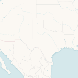
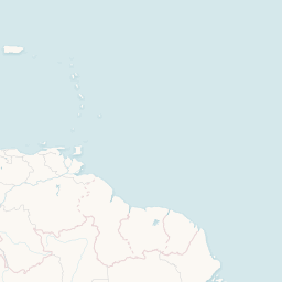
Pozos con fracking
Ubicación aproximada del yacimiento no convencional
less
more
x
Share this map
Social
Share on Facebook
Share on Twitter
Link to this map
Embed this map
<iframe width='100%' height='520' frameborder='0' src='https://cartocritica.carto.com/viz/b2c288eb-1b7c-43d0-a29e-bb7659b03514/embed_map' allowfullscreen webkitallowfullscreen mozallowfullscreen oallowfullscreen msallowfullscreen></iframe>
Visible layers
3
untitled_table_2
lindblad_especies_region_promedios_copy
frackingveracruz
+
-
CARTO
This visualization only works in modern browsers. Upgrade yours and enjoy.
Safari
Chrome
Firefox
cartocritica
Maps
Edit in CARTO
Untitled map
over 7 years ago
490 mapviews
More info
Datasets in use
untitled_table_2
public
0 rows
over 7 years ago
lindblad_especies_region_promedios_copy
public
44 rows
about 8 years ago
frackingveracruz
public
73 rows
over 10 years ago
More from cartocritica
Extracción ilegal de agua subterránea por acuífero
over 2 years ago
Untitled Map
over 2 years ago
Tomas clandestinas a Pemex 2008-2016
about 6 years ago